الصحراء الكبرى
( Sahara )
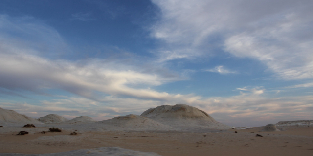
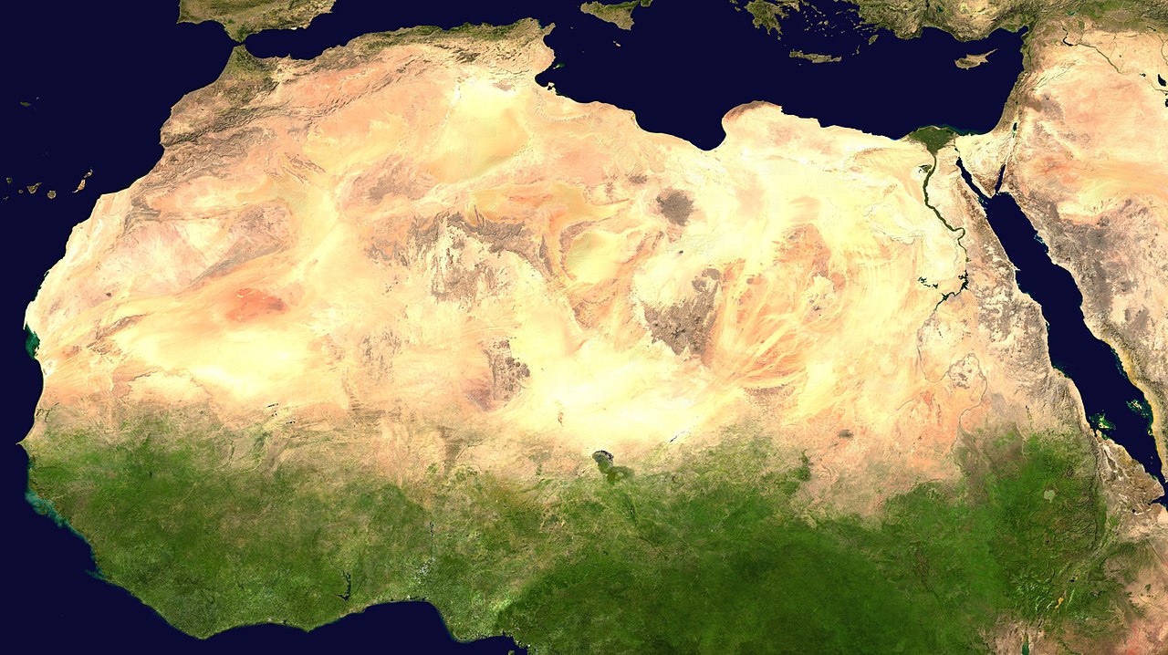
The Sahara (, ) is a desert spanning across North Africa. With an area of 9,200,000 square kilometres (3,600,000 sq mi), it is the largest hot desert in the world and the third-largest desert overall, smaller only than the deserts of Antarctica and the northern Arctic.
The name "Sahara" is derived from Arabic: صَحَارَى, romanized: ṣaḥārā /sˤaħaːraː/, a broken plural form of ṣaḥrā' (صَحْرَاء /sˤaħraːʔ/), meaning "desert".
The desert covers much of North Africa, excluding the fertile region on the Mediterranean Sea coast, the Atlas Mountains ...Read more
The Sahara (, ) is a desert spanning across North Africa. With an area of 9,200,000 square kilometres (3,600,000 sq mi), it is the largest hot desert in the world and the third-largest desert overall, smaller only than the deserts of Antarctica and the northern Arctic.
The name "Sahara" is derived from Arabic: صَحَارَى, romanized: ṣaḥārā /sˤaħaːraː/, a broken plural form of ṣaḥrā' (صَحْرَاء /sˤaħraːʔ/), meaning "desert".
The desert covers much of North Africa, excluding the fertile region on the Mediterranean Sea coast, the Atlas Mountains of the Maghreb, and the Nile Valley in Egypt and the Sudan.
It stretches from the Red Sea in the east and the Mediterranean in the north to the Atlantic Ocean in the west, where the landscape gradually changes from desert to coastal plains. To the south it is bounded by the Sahel, a belt of semi-arid tropical savanna around the Niger River valley and the Sudan region of sub-Saharan Africa. The Sahara can be divided into several regions, including the western Sahara, the central Ahaggar Mountains, the Tibesti Mountains, the Aïr Mountains, the Ténéré desert, and the Libyan Desert.
For several hundred thousand years, the Sahara has alternated between desert and savanna grassland in a 20,000-year cycle caused by the precession of Earth's axis (about 26,000 years) as it rotates around the Sun, which changes the location of the North African monsoon.
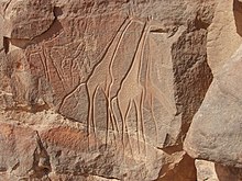 Saharan rock art in the Fezzan
People lived on the edge of the desert thousands of years ago,[1] since the end of the last glacial period. In the Central Sahara, engraved and painted rock art were created perhaps as early as 10,000 years ago, spanning the Bubaline Period, Kel Essuf Period, Round Head Period, Pastoral Period, Caballine Period, and Cameline Period.[2] The Sahara was then a much wetter place than it is today. Over 30,000 petroglyphs of river animals such as crocodiles[3] survive, with half found in the Tassili n'Ajjer in southeast Algeria. Fossils of dinosaurs,[4] including Afrovenator, Jobaria and Ouranosaurus, have also been found here. The modern Sahara, though, is not lush in vegetation, except in the Nile Valley, at a few oases, and in the northern highlands, where Mediterranean plants such as the olive tree are found to grow. Shifts in Earth's axis increased temperatures and decreased precipitation, which caused an abrupt beginning of North Africa desertification about 5,400 years ago.[5]
KiffiansThe Kiffian culture is a prehistoric industry, or domain, that existed between 10,000 and 8,000 years ago in the Sahara, during the Neolithic Subpluvial. Human remains from this culture were found in 2000 at a site known as Gobero, located in Niger in the Ténéré Desert.[6] The site is known as the largest and earliest grave of Stone Age people in the Sahara.[7] The Kiffians were skilled hunters. Bones of many large savannah animals that were discovered in the same area suggest that they lived on the shores of a lake that was present during the Holocene Wet Phase, a period when the Sahara was verdant and wet.[7] The Kiffian people were tall, standing over six feet in height.[6] Craniometric analysis indicates that this early Holocene population was closely related to the Late Pleistocene Iberomaurusians and early Holocene Capsians of the Maghreb, as well as mid-Holocene Mechta groups.[8] Traces of the Kiffian culture do not exist after 8,000 years ago, as the Sahara went through a dry period for the next thousand years.[9] After this time, the Tenerian culture colonized the area.
TeneriansGobero was discovered in 2000 during an archaeological expedition led by Paul Sereno, which sought dinosaur remains. Two distinct prehistoric cultures were discovered at the site: the early Holocene Kiffian culture, and the middle Holocene Tenerian culture. The post-Kiffian desiccation lasted until around 4600 BCE, when the earliest artefacts associated with the Tenerians have been dated to. Some 200 skeletons have been discovered at Gobero. The Tenerians were considerably shorter in height and less robust than the earlier Kiffians. Craniometric analysis also indicates that they were osteologically distinct. The Kiffian skulls are akin to those of the Late Pleistocene Iberomaurusians, early Holocene Capsians, and mid-Holocene Mechta groups, whereas the Tenerian crania are more like those of Mediterranean groups.[10][11] Graves show that the Tenerians observed spiritual traditions, as they were buried with artifacts such as jewelry made of hippo tusks and clay pots. The most interesting find is a triple burial, dated to 5300 years ago, of an adult female and two children, estimated through their teeth as being five and eight years old, hugging each other. Pollen residue indicates they were buried on a bed of flowers. The three are assumed to have died within 24 hours of each other, but as their skeletons hold no apparent trauma (they did not die violently) and they have been buried so elaborately – unlikely if they had died of a plague – the cause of their deaths is a mystery.
 Oued Zouzfana and village of TaghitTashwinat Mummy
Uan Muhuggiag appears to have been inhabited from at least the 6th millennium BCE to about 2700 BCE, although not necessarily continuously.[12] The most noteworthy find at Uan Muhuggiag is the well-preserved mummy of a young boy of approximately 2+1⁄2 years old. The child was in a fetal position, then embalmed, then placed in a sack made of antelope skin, which was insulated by a layer of leaves.[13] The boy's organs were removed, as evidenced by incisions in his stomach and thorax, and an organic preservative was inserted to stop his body from decomposing.[14] An ostrich eggshell necklace was also found around his neck.[12] Radiocarbon dating determined the age of the mummy to be approximately 5600 years old, which makes it about 1000 years older than the earliest previously recorded mummy in ancient Egypt.[15] In 1958–59, an archaeological expedition led by Antonio Ascenzi conducted anthropological, radiological, histological and chemical analyses on the Uan Muhuggiag mummy. The team claimed that the mummy was a 30-month-old child of uncertain sex. They also found a long incision on the specimen's abdominal wall, which indicated that the body had been initially mummified by evisceration and later underwent natural desiccation. The team also stated that the mummy possessed "Negroid features."[16] However, modern genetics has since proven that the final claim is unscientific and not supported by evidence.[17][18] A more recent publication referenced a laboratory examination of the cutaneous features of the child mummy in which the results verified that the child possessed a dark skin complexion.[19] One other individual, an adult, was found at Uan Muhuggiag, buried in a crouched position.[12] However, the body showed no evidence of evisceration or any other method of preservation. The body was estimated to date from about 7500 BP.[20]
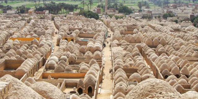
Nubians Beni Isguen, a holy city surrounded by thick walls in the Algerian Sahara
During the Neolithic Era, before the onset of desertification around 9500 BCE, the central Sudan had been a rich environment supporting a large population ranging across what is now barren desert, like the Wadi el-Qa'ab. By the 5th millennium BCE, the people who inhabited what is now called Nubia were full participants in the "agricultural revolution", living a settled lifestyle with domesticated plants and animals. Saharan rock art of cattle and herdsmen suggests the presence of a cattle cult like those found in Sudan and other pastoral societies in Africa today.[21] Megaliths found at Nabta Playa are overt examples of probably the world's first known archaeoastronomy devices, predating Stonehenge by some 2,000 years.[22] This complexity, as observed at Nabta Playa, and as expressed by different levels of authority within the society there, likely formed the basis for the structure of both the Neolithic society at Nabta and the Old Kingdom of Egypt.[23] Archaeological evidence has attested that population settlements occurred in Nubia as early as the Late Pleistocene era and from the 5th millennium BC onwards, whereas there is "no or scanty evidence" of human presence in the Egyptian Nile Valley during these periods, which may be due to problems in site preservation.[24]
EgyptiansBy 6000 BCE predynastic Egyptians in the southwestern corner of Egypt were herding cattle and constructing large buildings. Subsistence in organized and permanent settlements in predynastic Egypt by the middle of the 6th millennium BCE centered predominantly on cereal and animal agriculture: cattle, goats, pigs and sheep. Metal objects replaced prior ones of stone. Tanning of animal skins, pottery and weaving were commonplace in this era also. There are indications of seasonal or only temporary occupation of the Al Fayyum in the 6th millennium BCE, with food activities centering on fishing, hunting and food-gathering. Stone arrowheads, knives and scrapers from the era are commonly found.[25] Burial items included pottery, jewelry, farming and hunting equipment, and assorted foods including dried meat and fruit. Burial in desert environments appears to enhance Egyptian preservation rites, and the dead were buried facing due west.[26] Several scholars have argued that the African origins of the Egyptian civilisation derived from pastoral communities which emerged in both the Egyptian and Sudanese regions of the Nile Valley in the fifth millennium BCE.[27]
By 3400 BCE, the Sahara was as dry as it is today, due to reduced precipitation and higher temperatures resulting from a shift in Earth's orbit.[5] As a result of this aridification, it became a largely impenetrable barrier to humans, with the remaining settlements mainly being concentrated around the numerous oases that dot the landscape. Little trade or commerce is known to have passed through the interior in subsequent periods, the only major exception being the Nile Valley. The Nile, however, was impassable at several cataracts, making trade and contact by boat difficult.
Tichitt cultureIn 4000 BCE, the start of sophisticated social structure (e.g., trade of cattle as valued assets) developed among herders amid the Pastoral Period of the Sahara.[28] Saharan pastoral culture (e.g., fields of tumuli, lustrous stone rings, axes) was intricate.[29] By 1800 BCE, Saharan pastoral culture expanded throughout the Saharan and Sahelian regions.[28] The initial stages of sophisticated social structure among Saharan herders served as the segue for the development of sophisticated hierarchies found in African settlements, such as Dhar Tichitt.[28] After migrating from the Central Sahara, proto-Mande peoples established their civilization in the Tichitt region[30] of the Western Sahara[31] The Tichitt Tradition of eastern Mauritania dates from 2200 BCE[32][33] to 200 BCE.[34][35] Tichitt culture, at Dhar Néma, Dhar Tagant, Dhar Tichitt, and Dhar Walata, included a four-tiered hierarchal social structure, farming of cereals, metallurgy, numerous funerary tombs, and a rock art tradition[36] At Dhar Tichitt and Dhar Walata, pearl millet may have also been independently tamed amid the Neolithic.[37] Dhar Tichitt, which includes Dakhlet el Atrouss, may have served as the primary regional center for the multi-tiered hierarchical social structure of the Tichitt Tradition,[38] and the Malian Lakes Region, which includes Tondidarou, may have served as a second regional center of the Tichitt Tradition.[39] The urban[31] Tichitt Tradition may have been the earliest large-scale, complexly organized society in West Africa,[40] and an early civilization of the Sahara,[30][32] which may have served as the segue for state formation in West Africa.[29]
As areas where the Tichitt cultural tradition were present, Dhar Tichitt and Dhar Walata were occupied more frequently than Dhar Néma.[40] Farming of crops (e.g., millet) may have been a feature of the Tichitt cultural tradition as early as 3rd millennium BCE in Dhar Tichitt.[40]
As part of a broader trend of iron metallurgy developed in the West African Sahel amid 1st millennium BCE, iron items (350 BCE – 100 CE) were found at Dhar Tagant, iron metalworking and/or items (800 BCE – 400 BCE) were found at Dia Shoma and Walaldé, and the iron remnants (760 BCE – 400 BCE) found at Bou Khzama and Djiganyai.[40] The iron materials that were found are evidence of iron metalworking at Dhar Tagant.[35] In the late period of the Tichitt Tradition at Dhar Néma, tamed pearl millet was used to temper the tuyeres of a oval-shaped low shaft furnace; this furnace was one out of 16 iron furnaces located on elevated ground.[34] Iron metallurgy may have developed before the second half of 1st millennium BCE, as indicated by pottery dated between 800 BCE and 200 BCE.[34] At Dhar Walata and Dhar Tichitt, copper was also used.[31]
After its decline in Mauritania, the Tichitt Tradition spread to the Middle Niger region (e.g., Méma, Macina, Dia Shoma, Jenne Jeno) of Mali where it developed into and persisted as Faïta Facies ceramics between 1300 BCE and 400 BCE among rammed earth architecture and iron metallurgy (which had developed after 900 BCE).[41] Thereafter, the Ghana Empire developed in the 1st millennium CE.[41]
Phoenicians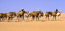 Azalai salt caravan. The French reported that the 1906 caravan numbered 20,000 camels.
The people of Phoenicia, who flourished from 1200 to 800 BCE, created a chain of settlements along the coast of North Africa and traded extensively with its inhabitants. This put them in contact with the people of ancient Libya, who were the ancestors of people who speak Berber languages in North Africa and the Sahara today.
The Libyco-Berber alphabet of the ancient Libyans of north Africa seems to have been based on Phoenician, and its descendant Tifinagh is still used today by the (Berber) Tuareg of the central Sahara.
The Periplus of the Phoenician navigator Hanno, who lived sometime in the 5th century BC, claims that he founded settlements along the Atlantic coast of Africa, possibly including the Western Sahara. The identification of the places discussed is controversial, and archeological confirmation is lacking.
GreeksBy 500 BCE, Greeks arrived in the desert. Greek traders spread along the eastern coast of the desert, establishing trading colonies along the Red Sea. The Carthaginians explored the Atlantic coast of the desert, but the turbulence of the waters and the lack of markets caused a lack of presence further south than modern Morocco. Centralized states thus surrounded the desert on the north and east; it remained outside the control of these states. Raids from the nomadic Berber people of the desert were of constant concern to those living on the edge of the desert.
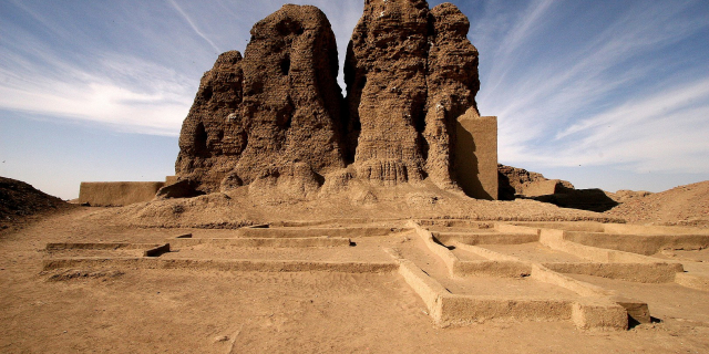
Garamantes Market on the main square of Ghardaïa (1971)
An urban civilization, the Garamantes, arose around 500 BCE in the heart of the Sahara, in a valley that is now called the Wadi al-Ajal in Fezzan, Libya.[42] The Garamantes built a prosperous empire in the heart of the desert.[43] The Garamantes achieved this development by digging tunnels far into the mountains flanking the valley to tap fossil water and bring it to their fields. The Garamantes grew populous and strong, conquering their neighbors, and capturing and enslaving many individuals who were forced to work by extending the tunnels. The ancient Greeks and the Romans knew of the Garamantes and regarded them as uncivilized nomads. However, they traded with them, and a Roman bath has been found in the Garamantes' capital of Garama. Archaeologists have found eight major towns and many other important settlements in the Garamantes' territory. The Garamantes' civilization eventually collapsed after they had depleted available water in the aquifers and could no longer sustain the effort to extend the tunnels further into the mountains.[44]
Between the first century BCE and the fourth century CE, several Roman expeditions into the Sahara were conducted by groups of military and commercial units of Romans.
Islamic and Arabic expansionThe Byzantine Empire ruled the northern shores of the Sahara from the 5th to the 7th centuries. After the Muslim conquest of Arabia, specifically the Arabian peninsula, the Muslim conquest of North Africa began in the mid-7th to early 8th centuries and Islamic influence expanded rapidly on the Sahara. By the end of 641 all of Egypt was in Muslim hands. Trade across the desert intensified, and a significant slave trade crossed the desert. It has been estimated that from the 10th to 19th centuries some 6,000 to 7,000 slaves were transported north each year.[45]
The Beni Ḥassān and other nomadic Arab tribes dominated the Sanhaja Berber tribes of the western Sahara after the Char Bouba war of the 17th century. As a result, Arabian culture and language came to dominate, and the Berber tribes underwent some Arabization.
Ottoman Turkish eraIn the 16th century the northern fringe of the Sahara, such as coastal regencies in present-day Algeria and Tunisia, as well as some parts of present-day Libya, together with the semi-autonomous kingdom of Egypt, were occupied by the Ottoman Empire. From 1517 Egypt was a valued part of the Ottoman Empire, ownership of which provided the Ottomans with control over the Nile Valley, the east Mediterranean and North Africa. The benefit of the Ottoman Empire was the freedom of movement for citizens and goods. Traders exploited the Ottoman land routes to handle the spices, gold and silk from the East, manufactured goods from Europe, and the slave and gold traffic from Africa. Arabic continued as the local language and Islamic culture was much reinforced. The Sahel and southern Sahara regions were home to several independent states or to roaming Tuareg clans.
European colonialismEuropean colonialism in the Sahara began in the 19th century. France conquered the regency of Algiers from the Ottomans in 1830, and French rule spread south from French Algeria and eastwards from Senegal into the upper Niger to include present-day Algeria, Chad, Mali then French Sudan including Timbuktu (1893), Mauritania, Morocco (1912), Niger, and Tunisia (1881). By the beginning of the 20th century, the trans-Saharan trade had clearly declined because goods were moved through more modern and efficient means, such as airplanes, rather than across the desert.[46]
The French took advantage of long-standing animosity between the Chaamba Arabs and the Tuareg. The newly raised Méhariste camel corps were originally recruited mainly from the Chaamba nomadic tribe. In 1902, the French penetrated the Hoggar mountains and defeated Ahaggar Tuareg in the battle of Tit.
 The French colonial empire (blue) was the dominant presence in the Sahara.
The French Colonial Empire was the dominant presence in the Sahara. It established regular air links from Toulouse (HQ of famed Aéropostale), to Oran and over the Hoggar to Timbuktu and West to Bamako and Dakar, as well as trans-Sahara bus services run by La Compagnie Transsaharienne (est. 1927).[47] A remarkable film shot by famous aviator Captain René Wauthier in 1933 documents the first crossing by a large truck convoy from Algiers to Tchad, across the Sahara.[48]
Egypt, under Muhammad Ali and his successors, conquered Nubia in 1820–22, founded Khartoum in 1823, and conquered Darfur in 1874. Egypt, including Sudan, became a British protectorate in 1882. Egypt and Britain lost control of the Sudan from 1882 to 1898 as a result of the Mahdist War. After its capture by British troops in 1898, the Sudan became an Anglo-Egyptian condominium.
Spain captured present-day Western Sahara after 1874, although Rio del Oro remained largely under Sahrawi influence. In 1912, Italy captured parts of what was to be named Libya from the Ottomans. To promote the Roman Catholic religion in the desert, Pope Pius IX appointed a delegate Apostolic of the Sahara and the Sudan in 1868; later in the 19th century his jurisdiction was reorganized into the Vicariate Apostolic of Sahara.
Breakup of the empires and afterwards A natural rock arch in south western Libya
 The Sahara today
Egypt became independent of Britain in 1936, although the Anglo-Egyptian treaty of 1936 allowed Britain to keep troops in Egypt and to maintain the British-Egyptian condominium in the Sudan. British military forces were withdrawn in 1954.
Most of the Saharan states achieved independence after World War II: Libya in 1951; Morocco, Sudan, and Tunisia in 1956; Chad, Mali, Mauritania, and Niger in 1960; and Algeria in 1962. Spain withdrew from Western Sahara in 1975, and it was partitioned between Mauritania and Morocco. Mauritania withdrew in 1979; Morocco continues to hold the territory (see Western Sahara conflict).[49]
Tuareg people in Mali rebelled several times during the 20th century before finally forcing the Malian armed forces to withdraw below the line demarcating Azawad from southern Mali during the 2012 rebellion.[50] Islamist rebels in the Sahara calling themselves al-Qaeda in the Islamic Maghreb have stepped up their violence in recent years.[51]
In the post–World War II era, several mines and communities have developed to use the desert's natural resources. These include large deposits of oil and natural gas in Algeria and Libya, and large deposits of phosphates in Morocco and Western Sahara.[52] Libya's Great Man-Made River is the world's largest irrigation project.[53] The project uses a pipeline system that pumps fossil water from the Nubian Sandstone Aquifer System to cities in the populous Libyan northern Mediterranean coast including Tripoli and Benghazi.[54]
A number of Trans-African highways have been proposed across the Sahara, including the Cairo–Dakar Highway along the Atlantic coast, the Trans-Sahara Highway from Algiers on the Mediterranean to Kano in Nigeria, the Tripoli – Cape Town Highway from Tripoli in Libya to N'Djamena in Chad, and the Cairo – Cape Town Highway which follows the Nile. Each of these highways is partially complete, with significant gaps and unpaved sections.


Add new comment